
World Rivers Day Celebrates Rivers as Earth's Arteries
Posted by Bill Davis on Sep 25th 2026
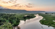
Rivers are the arteries of the planet -- and World Rivers Day, September 27, 2026, is the day to acknowledge their importance. The tradition goes back to 1980, when Canadian conservationist Mark Angelo started it as BC Rivers Day, before taking it global in 2005. It's now recognized in 100+ countries, usually with cleanups and water-quality pledges, worthy things a river never gets much credit for outside a day named after it.
Stanford's Earth and Planetary Sciences department puts that comparison plainly: rivers are "the arteries of Earth's continents, conveying water, sediments, and solutes from the headwaters to the oceans." They form high up, flow down to the sea, loop back through the sky as rain, and, almost as an afterthought, build the beach under your towel along the way.
- World Rivers Day 2026 falls on Sunday, September 27, always the fourth Sunday of September.
- Rivers form at a source, usually a melting glacier, mountain snowmelt, or an outflowing lake, and grow as tributaries join them on the way downhill.
- Geologists call rivers the arteries of the continents: they move water, sediment, and nutrients from headwaters to ocean, then cycle back as rain (aka the water cycle).
- One of the quieter things a river carries is the sand under a beach towel -- and dams that block its flow can cut that supply off.
- Flow can come back: after two dams came out of Washington's Elwha River, it rebuilt close to 27 hectares of coastline in five years.
Where Does a River Begin?
Every river starts somewhere, usually a spot geologists call its source, or headwaters. Most of the time that's a melting glacier, mountain snowmelt, or a lake with a stream flowing out of it, according to National Geographic's rivers education resource. The Ganges, one of the world's most storied rivers, begins at India's Gangotri Glacier, high in the Himalayas.
From there, gravity does the rest. Water moves downhill as a small stream, gaining size wherever a tributary, a smaller stream or river, joins the flow. The Amazon alone takes in water from more than 1,000 tributaries before it ever reaches the Atlantic.
How Does a River Find Its Way to the Sea?
How fast a river moves depends mostly on slope: the steeper the ground it's crossing, the faster the water runs, since gravity is doing the work. That's why a river tends to move quickly through mountains and slow into wide, meandering bends once it reaches flatter ground closer to the coast.
Most rivers end their trip the same way, flowing into the ocean, per National Geographic, carrying with them everything they've picked up along the route: water, nutrients, sediment, and more. That handoff at the coastline is where a river's job as an "artery" becomes visible -- it's delivering, all at once, everything a stretch of land has been shedding for miles upstream.
Want to see that route mapped out? An interactive tool called River Runner lets you click anywhere in the contiguous U.S. and watch a simulated raindrop travel, river by river, all the way to the ocean it eventually reaches -- a fast way to see a river's actual route, not just read about one.
Rivers Are the Arteries of the Planet
That comparison holds up at scale. A river moves water, sediment, and dissolved solutes from a continent's highest points down to its oceans, the same way an artery moves blood from the heart out to the rest of a body -- which is exactly why geologists reach for the word in the first place.
That movement is what makes river valleys some of the most fertile, most heavily settled land on Earth. Floodplains built by centuries of river sediment support agriculture and cities alike. Rivers have doubled as trade routes for as long as people have built boats. World Rivers Day exists, per founder Mark Angelo's own framing, to highlight the many values of our rivers -- this is one of the biggest ones, even when it's easy to take for granted. It's also part of why caring about water systems shows up in how we do business, not just what we sell.
How Do Rivers Complete the Water Cycle?
A river's other job is closing a loop. NOAA breaks that loop into a few key stages:
- Evaporation and condensation -- water rises off the ocean and forms clouds.
- Precipitation -- it falls back to land as rain or snow, the part of the cycle most people picture first.
- Runoff and streamflow -- in NOAA's own terms, water moves across the land's surface through lakes, streams, and rivers, headed back to the sea.
- Infiltration and percolation -- some of it soaks into the soil and down into groundwater instead of reaching a river.
A river is the most direct route back to where the cycle started.
A Quieter Job: Building the Beaches We Love

Photo: Sardar Faizan / Unsplash
Rivers do this job with less fanfare, but it's real: sand doesn't just show up at the coast. Every grain used to be rock or soil somewhere upstream, and a river is what actually carries it the rest of the way, sometimes over centuries, before waves and longshore currents spread it into the beach you're standing on.
A landmark 2005 study in the journal Science, led by geologist James Syvitski, found dams and reservoirs, built mostly in the last 50 years, now hold back more than 100 billion metric tons of sediment that would otherwise be working its way toward a coastline, cutting the amount that actually reaches the coast by an estimated 1.4 billion metric tons a year.

Photo: Zongnan Bao / Unsplash
California shows what that looks like at a regional scale. Researchers Christine Willis and Gary Griggs, publishing in the Journal of Geology in 2003, found the state's 500-plus dams have cut the sand and gravel reaching its 20 major beach systems by roughly 25%.
What Happens When an Artery Reopens?
Sediment starvation isn't necessarily permanent, and the clearest proof is Washington's Elwha River, on the Olympic Peninsula. Two dams blocked it for most of the 20th century; by the early 2000s the U.S. Geological Survey found the shoreline near the river mouth had been eroding at nearly 2 feet a year since 1939, with roughly 20 million cubic meters of sediment trapped behind the dams, going nowhere.
Both dams came out between 2011 and 2014. According to a 2024 study led by researcher Duda in Frontiers in Ecology and Evolution, the Elwha carried an estimated 20.5 million metric tons of sediment downstream in the first five years after removal, and the delta gained close to 27 hectares of new land. A portion eroded back as the system settled into a new balance, tracked as expected, not a failure. On net, the coastline grew, once the river was allowed to run the way it always had.
A larger version of the same story is unfolding on the Klamath River, along the Oregon-California border. Four dams, J.C. Boyle, Copco No. 1, Copco No. 2, and Iron Gate, came out between 2023 and 2024, the largest dam removal project in U.S. history, surpassing the Elwha and reopening more than 400 miles of river habitat. An estimated 15.5 million cubic yards of sediment had built up behind those dams, and FERC (the Federal Energy Regulatory Commission) projected more than a third of it would move downstream. The final cofferdams came down on August 28, 2024, and the river now flows freely to the Pacific for the first time in more than a century -- American Rivers reports that testing on the released sediment found it was mostly dead algae, not a concern for human health, with restoration crews now focused on revegetating the former reservoir footprint.
Want more on who's actually doing that restoration and advocacy work? See our profile of the freshwater conservation partners we support -- a different angle on rivers than the one covered here.
The Sediment Math, Side by Side
Four different data points, four different scales, one pattern:
| Where | What Happened | Sediment Involved | Result |
|---|---|---|---|
| Worldwide | Dams built, mostly in the last ~50 years | ~100 billion metric tons trapped; ~1.4 billion metric tons/year no longer reaching coastlines | Ongoing global sediment shortfall |
| California | 500+ dams across the state's coastal watersheds | 2.8 million cubic meters/year cut, a 25% reduction | Sediment loads declined in 70% of streams studied; ongoing beach erosion |
| Elwha River, WA | Two dams removed, 2011-2014 | 20.5 million metric tons carried downstream in 5 years; 5.4 million tons reached the delta | Delta gained close to 27 hectares of new land |
| Klamath River, OR/CA | Four dams removed, 2023-2024 | 15.5 million cubic yards held behind the dams; 36-57% projected to move downstream | River flowing freely since Aug. 2024; released sediment confirmed non-hazardous (mostly dead algae) |
Sources: Syvitski et al., Science (2005); Willis & Griggs, Journal of Geology (2003); Duda et al., Frontiers in Ecology and Evolution (2024); American Rivers, "Dam Removal on the Klamath River".
The Bottom Line
Rivers get celebrated on World Rivers Day for water quality, wildlife, and recreation, real reasons, all of them. The bigger picture is the one Stanford's geologists point to directly: rivers are the arteries of the planet, moving water from headwaters to ocean and back again through the sky, carrying sediment, nutrients, and life the whole way. Building a beach is one small, visible part of that job, and it's a part dams can quietly switch off for decades before anyone notices. The Elwha proves the damage isn't necessarily permanent; whether the Klamath tells the same story is still being measured.
None of this is something you fix with a purchase, and we're not going to pretend otherwise. But in the spirit of a day built around noticing what rivers actually do, here's a few things worth keeping around.
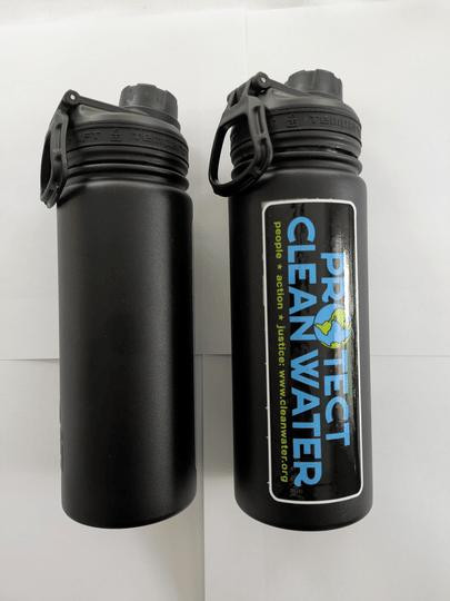
Clean Water Fund 18 oz Black Tempercraft Water Bottle, $19.95
18/8 stainless steel, vacuum insulated, double-wall construction that keeps drinks cold up to 24 hours and hot for 6 or more. Sports lid, BPA-free, hand wash only.
Why we carry this: a bottle you keep for years is one less thing manufactured, shipped, and eventually landfilled on a repeat cycle. Every bottle is also a rescued factory misprint, and 75% of proceeds fund Clean Water Fund's freshwater initiatives directly.

Kona Flannels Collection, $98.95
100% cotton long-sleeve flannel shirts in five coastal colorways, built with a thicker weave for warmth as evenings cool off. Each shirt comes with its own attached sunglass-cleaning cloth, per the brand's own product description.
Why we carry these: a flannel that's actually built for beach evenings, not borrowed from a ski cabin, tends to get worn for years instead of one season.

Women's Tulip 139

Men's Tulip 140
Ilse Jacobsen Tulip Slip-Ons -- Women's 139, $94.95 / Men's 140, $99.95
Lightly cushioned, perforated slip-ons with a soft microfiber lining, designed by Ilse Jacobsen in Hornbaek, Denmark, a seaside town on the Oresund strait. Easy to wear from the car to the sand and back.
Why we carry these: a slip-on built by a brand headquartered on the water, made for exactly the kind of quick beach-to-errand days this time of year brings.
Gear worth keeping, for the days you spend near the water.
Frequently Asked Questions
When is World Rivers Day 2026?
World Rivers Day falls on September 27, 2026, the fourth Sunday of September, when it's observed every year. Canadian conservationist Mark Angelo founded it in 2005, growing the event out of BC Rivers Day, which he started in 1980. It's now marked in up to 100 countries.
Why are rivers called the arteries of the planet?
Geologists use the comparison because rivers do for the continents what arteries do for a body: carry water, sediment, and dissolved minerals from the highest points on land, called headwaters, down to the ocean. Stanford's Earth and Planetary Sciences department uses this exact framing to describe how rivers move material across a landscape.
How do rivers form?
Most rivers start at a source, or headwaters, fed by a melting glacier, mountain snowmelt, or a lake with an outflowing stream. Gravity pulls the water downhill as a small stream, and it picks up volume from tributaries, smaller streams and rivers that feed into it, along the way. The Ganges, for example, begins at India's Gangotri Glacier.
What role do rivers play in the water cycle?
Rivers are the part of the water cycle that carries rainfall, snowmelt, and groundwater runoff across the land's surface back to the ocean, where it evaporates, forms clouds, and eventually falls as precipitation again. NOAA describes this stage as runoff and streamflow, one of several steps, alongside evaporation, condensation, infiltration, and percolation, that keep water moving through the cycle.
Do rivers really build the beaches we visit?
Yes. Rivers carry sediment, mostly sand and silt worn down from rock and soil inland, downstream to the coast, where it gets deposited at river mouths and spread along the shoreline by waves and currents. It's a slower, quieter job than the water cycle, but a large share of the sand under a beach towel got there by river.
Does removing a dam actually bring a beach back?
It can. After two dams came out of Washington's Elwha River between 2011 and 2014, the river carried over 20 million metric tons of sediment downstream in the next five years, and its delta gained close to 27 hectares of new land. A larger dam removal project on the Klamath River finished in August 2024, and the river now flows freely to the Pacific for the first time in over a century, though researchers haven't yet published coastal sediment data comparable to Elwha's.